Map Elements: a Note on Source Notes
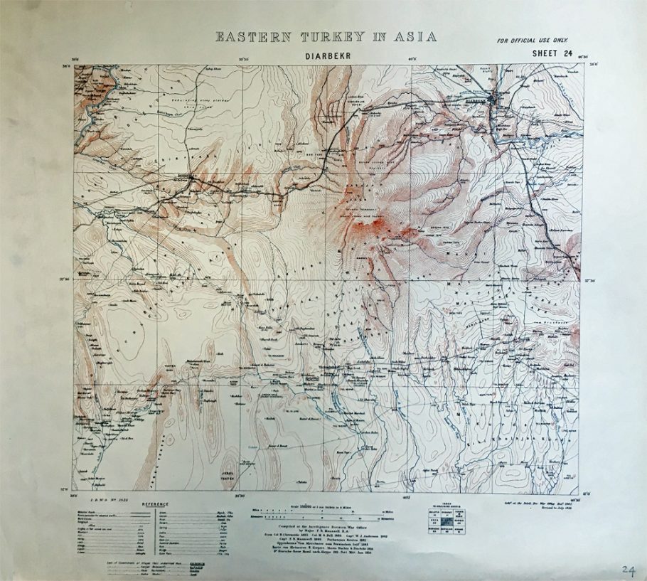
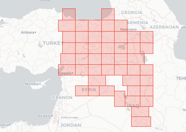
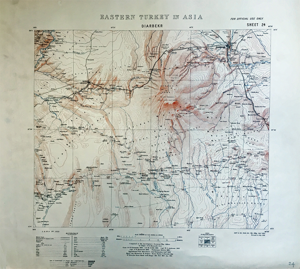
What’s in a Map? Maps contain common elements: by definition there is the actual “map” – a conventionalised visual representation, usually two dimensional, of geographic space – but often a title, scale, and some type of orientation in the form of a compass rose or latitude and longitude lines. In addition, maps may contain other elements such as inset map(s), legends for symbols, statistical lists, small index maps if part of a series, publisher and date, name of the cartographer and/or lithographer, and source notes. What interests me here is the last element – the source notes. Some maps in the BSA Map Collection contain minimal source notes – “based on a Kiepert map”, for example. However, the extensive source notes on one map series caught my attention: Eastern Turkey in Asia. Forty-seven conjoining sheets from this British military series exist in the BSA Map Collection, the coverage seen in the image below. The series dates from 1901 to 1918 and covers eastern Anatolia along with parts of Mesopotamia, all part of the Ottoman Empire. The maps were given the series numbers 1522 and 1522a, preceded by the acronym I.D.W.O. (Intelligence Division War Office) and later, after WWI, the acronym G.S.G.S. (General Staff Geographical Service).
All of these maps were a result of British covert intelligence operations. Their source notes begin with the wording: “Compiled at the Intelligence Division, War Office by Major F.R. Maunsell, R.A.”, and the maps published post-WWI begin with the variation, “Compiled for the Geographical Section, General Staff by Lieut. Colonel F.R. Maunsell C.M.G.”. Following this formulaic introduction are a series of names (often reduced to title/rank and a surname) who are sometimes listed as making reconnaissances, obscure and abbreviated bibliographic references, abridged titles of official government maps and reports, and a series of other maps and sketches in shorthand code. The list of sources is very perplexing, albeit intriguing as they represent the exploration of a part of what was then a little known area of the Ottoman Empire – a bit of history told in compact summary form. It just requires decoding.
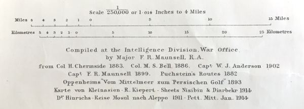
Compiled at the Intelligence Division, War Office / by Major F.R. Maunsell, R.A. / from Col. Chermside 1883. Col. M.S.. Bell 1886. Capt W.J. Anderson 1902 / Capt. F.R. Maunsell 1899. Puchstein’s Routes 1882 / Oppenheims “Vom Mittelmeer zum Persischen Golf” 1893 / Karte von Kleinasien – R. Kiepert – Sheets Nisibin & Diarbekr 1914 / Dr. Hinrichs – Reise Mosul nach Aleppo 1911 – Pett. Mitt. 1914.
Part I: First-hand Observations
Let’s first start with F.R. Maunsell, the compiler of the series. Francis Richard Maunsell (1861–1936) has been described as a diplomat, amateur archaeologist, and cartographer. He was a British Army officer who served in military intelligence mostly in the Middle East from the late nineteenth century until the early part of the twentieth. He also served as Vice-Consul in Sivas (1897-1898) and Van (1898-1901), as military attache at Constantinople (1901-1905) and as acting Consul in Trebizond (1908). The source notes reflect his promotion in rank from Major to Lieutenant-Colonel and his later investment as Commander of the Order of St. Michael and St. George (C.M.G.), an honour often given to officials who served overseas. Maunsell was also a member of the Royal Geographical Society, did some cartographic work for the Society and presented a number of papers at various meetings. He is mentioned on many of the maps in this series as conducting reconnaissances in 1888-1889, 1892, and 1897-1900. The coverage of his actual ground surveys is seen in the image below which corresponds roughly to the historic territory of Kurdistan, the subject of two papers Maunsell presented at the Royal Geographical Society. He also published (under the initials F.R.M.) notes to accompany the series in The Geographical Journal in 1906 which help interpret some of the source notes.
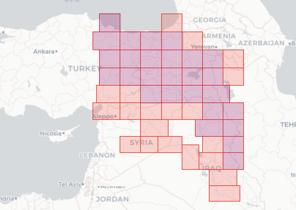
Coverage of the Eastern Turkey in Asia map series in the BSA’s Digital Collections showing Maunsell’s own reconnaissances in purple.
Who were the other individuals mentioned on the maps that provided first-hand information? Most of them were military personnel attached to various consulates held by the British in every province of the Ottoman Empire. Colonel Mark Sever Bell, Captain F. Bennet, Colonel Herbert Chermside, Major Gilbert Falkingham Clayton, Captain Bertram Dickson, Major William Everett, Captain Trenchard Craven William Fowle, Lieutenant J.J. Leverson, Lieutenant Henry Phillip Picot, Captain Mark Sykes, and Colonel H. Stewart are some of the military personnel mentioned in the source notes who were attached to consulates. Some of them went on to have diplomatic careers: Chermside as Governor of Queensland in 1902, Clayton as Civil Secretary of Palestine in the 1920s and later High Commissioner of the British Mandate of Mesopotamia (Iraq), and Fowle as the Chief Political Resident of the Persian Gulf in the 1930s. Non-military personnel, Henry Charles Hony and George Pollard Devey, also held similar positions in consulates – Hony in Mosul, and Devey in Erzerum and Van. In effect these individuals associated with the consulates acted as de-facto intelligence agents.
Still others were scholars such as Mr Ellsworth Huntington or missionaries such as Rev. Alpheus N. Andrus who had ties to the area. Huntington was a geographer who taught at the Euphrates College in Elaziğ (an American missionary high school) from 1897-1901 and would later become a professor at Yale. Andrus was a missionary for the American Board of Commissions for Foreign Missions based in Mardin from 1868 until 1915 when he was detained by Turkish authorities after the publication of a letter describing his eyewitness account of the Armenian genocide. One famous name stands out: Gertrude Margaret Lowthian Bell who is listed as providing cartographic information for two of the maps near the Euphrates. A number of these individuals, like Maunsell, were fellows of the Royal Geographical Society – including Miss Bell who was one of the first female fellows to be elected. A few of the individuals published accounts of their various journeys in the area of Eastern Turkey and Mesopotamia, often in The Geographical Journal, that corresponded to the maps in the series:
Bell, G. 1910. ‘The East Bank of the Euphrates from Tel Ahmar to Hit’, The Geographical Journal, 36(5): 513–537.
Dickson, B. 1910. ‘Journeys in Kurdistan’, The Geographical Journal, 35(4): 357–378.
Fowle, T. C. 1916.Travels in the Middle East, being impressions by the way in Turkish Arabia, Syria and Persia, by Captain T.C. Fowle. London: Smith, Elder and Co.
Huntington, E. 1902. ‘Through the Great Cañon of the Euphrates River’, The Geographical Journal, 20(2): 175-200.
Maunsell, F.R. 1894. ‘Kurdistan’, The Geographical Journal, 3(2): 81–92.
Maunsell, F.R. 1901. ‘Central Kurdistan’, The Geographical Journal, 18(2):121–141.
Maunsell, F.R. 1906. ‘Notes to Accompany Lieut.-Colonel Maunsell’s Map of Eastern Turkey in Asia’, The Geographical Journal, 28(2): 163–165.
Sykes, M. 1904. Dar-ul-Islam. A record of a journey through ten of the Asiatic Provinces of Turkey. London: Bickers & Son.
Sykes, M. 1907. ‘Journeys in North Mesopotamia’, The Geographical Journal, 30(3), pp. 237–254.
Sykes, M. 1907. ‘Journeys in North Mesopotamia (Continued)’, The Geographical Journal, 30(4), pp. 384–398.
Part II. Military Maps and Admiralty Charts
The source notes also make mention of military maps. The Imperial Russian maps dating to the last two decades of the 19th century are mentioned frequently. They use the term Verst, an obsolete unit of measurement for length which denotes the scale of the maps. One Verst is 1.0668 kilometres, making 5 Verst a 1:210,000 scale for the most commonly cited maps. Another map mentioned was a combined Russian and British endeavour, the production of the Turco-Persian Frontier map. According to the account by Colonel C.H.D. Ryder in The Geographical Journal this map was originally compiled between 1849 and 1855. The demarcation, however, was interrupted by various conflicts: the Crimean War (1853-1856), the Serbian–Ottoman Wars (1876–1878) and the Russo-Turkish War (1877-1878). The final demarcation lines were established in 1913-14 and the resulting map series was given the G.S.G.S. Number 2715. Additionally, a number of British Admiralty Charts were consulted – from the mid-19th-century/early-20th century revisions. The areas covered the Black Sea Coast of Turkey (Nos 2216, 2220, and 2235-2237) and the area near Alexandretta (modern İskenderun) on the Syrian coast (Nos 2188, 2632, and 2791). Some of the charts were details of harbours. The charts listed on the Black Sea are outlined in the image below.
Ryder, C.H.D. 1925. ‘The Demarcation of the Turco-Persian Boundary in 1913-14’, The Geographical Journal, 66(3): 227–237.
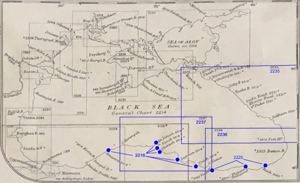
BSA Map Collection Section 9, Index: Admiralty Chart Index ca. 1914: Black Sea Insert with charts. Charts mentioned Eastern Turkey in Asia series marked in blue
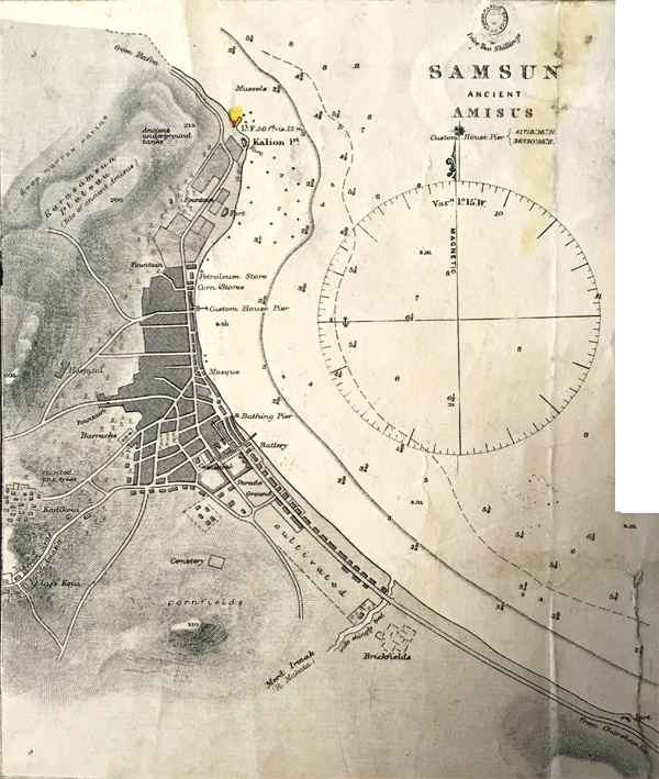
BSA Map Collection Section 12, No. 10 (b): Turkish Ports on the South Coast of the Black Sea: Samsun (Ancient Amisus). Surveyed by Captain Thomas Spratt.
Part III: Bibliography Cited
Travel accounts, publications of scientific expeditions and archaeological explorations are among the bibliography listed in abbreviated form. Sometimes the dates refer to the date of the expedition or journey and sometimes to the publication date. Also included in the list are published maps – sometimes part of a map series, or text publications. The publishers listed are known to specialise in maps and geography such as Justus Perthes, Dietrich Reimer and Edward Stanford. Prominent geographic journals are also well represented: Petermanns Geographische Mitteilungen (Pett. Mitt.) and The Geographical Journal, Zeitschrift der Gesellschaft für Erdkunde zu Berlin, and Bulletin de la Société de géographie. Also listed are official reports of the British government (primarily the India Office) and miscellaneous sketches and maps which are harder to track down, but some of the official reports are available in the India Office Papers at the British Library.
One of the earliest accounts consulted was Colonel Chesney’s Euphrates Expedition carried out between 1835 and 1837, originally published in 1850 as The expedition for the survey of the rivers Euphrates and Tigris with a further volume of the expedition published in 1868. Prior to the opening of the Suez canal, it was thought that great economic advantage might be had by transporting goods from the Mediterranean and along the Euphrates as a faster route to India (instead of around the southern tip of Africa). An expedition to explore this possibility was mounted, but it also gathered scientific and archaeological observations, in a similar format to the earlier French scientific expeditions Description de l’Égypte and Expédition de Morée. William Ainsworth was a member of Chesney’s expedition and served as physician and geologist. His later travel publication is listed in the source notes.
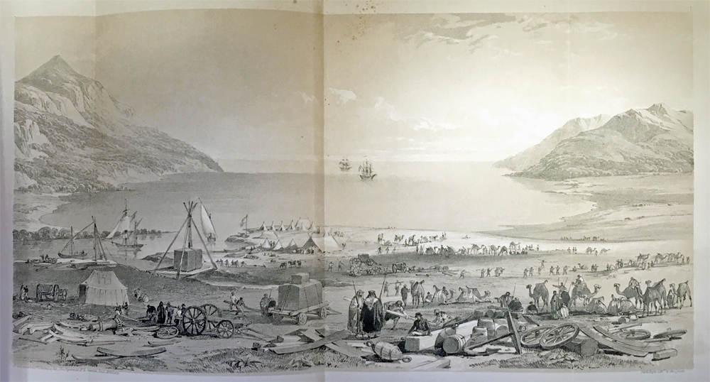
Frontispiece from Chesney’s Euphrates Expedition, from the BSA George Finlay collection (Fin. B 238). The Last Caravan preparing to leave Amelia Depôt [camp at the mouth of the Orontes River on the Syrian coast]. Drawn by Lieutenant-Colonel Estcourt 43rd Light Infantry and figures by Mr A. Staunton Royal Artillery.
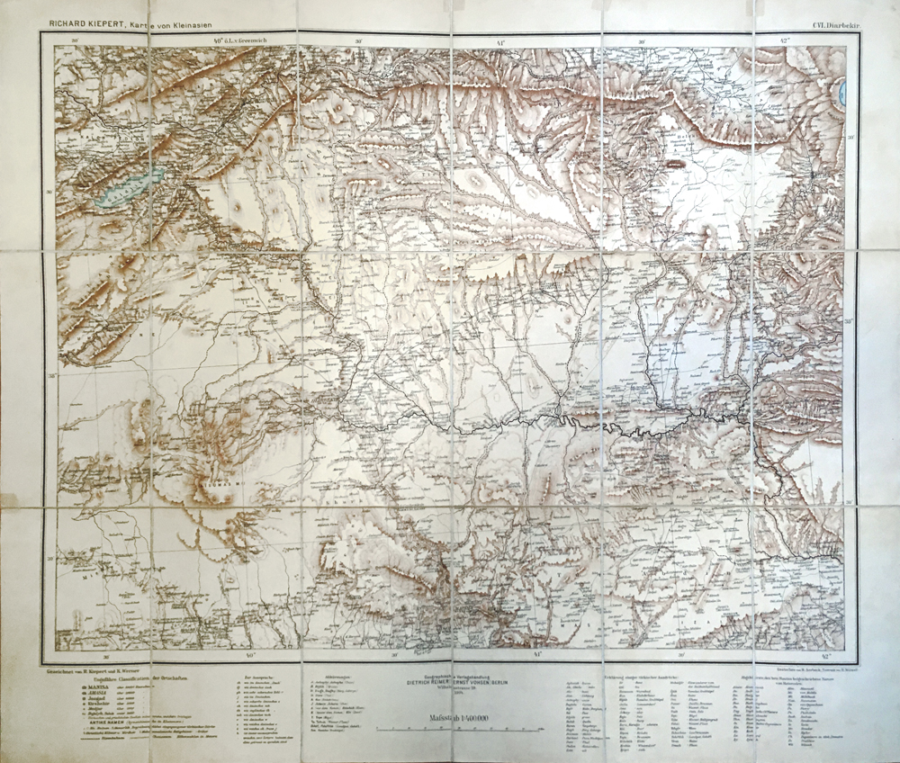
Another scientific mission mentioned in the source notes was carried out by Jacques de Morgan to Persia in 1889-1891. This expedition produced a total of ten volumes: four on geology; two on archaeology; one dedicated to Kurdish dialects and the languages of northern Persia; one of Mandaean texts; and two on geography. Other cited works in the source notes for Eastern Turkey in Asia series include those by botanists (Heinrich von Handel Mazetti, Carl Haussknecht), geologists (William Ainsworth, Max Blanckenhorn), orientalists (Martin Hartmann, Eduard Sachau), and archaeologists (Austen Henry Layard, Max Freiherr Oppenheim, Otto Puchstein, Friedrich Sarre and Ernst Herzfeld). Maps and map series by noted cartographers, particularly Heinrich Kiepert and his son Richard Kiepert, are also listed in the source notes, one of which is pictured below.
Publications: Books, Articles and Maps
Ainsworth, William. 1842.Travels and researches in Asia Minor, Mesopotamia, Chaldea, and Armenia. London: John W. Parker.
Blanckenhorn, Max 1891.Grundzüge der Geologie und physikalischen Geographie von Nord-Syrien: eine geologisch-geographische Skizze. Berlin: Friedländer.
Chesney, Francis Rawdon. 1850. The expedition for the survey of the rivers Euphrates and Tigris. London: Longmans, Green, and Co.
Chesney, Francis Rawdon. 1868. Narrative of the Euphrates expedition carried on by order of the British government during the years 1835, 1836, and 1837. London: Longmans, Green, and Co.
Flottwell, Bruno Hassenstein, Carl Schmidt, and Hans-Hoyer von Prittwitz und Gaffron. 1895. Wege-Aufnahmen im Gebiet des unteren Qyzyl Yrmaq (Halys), Juli bis Dezember 1893. Gotha: Justus Perthes.
Green, F. W. 1896. Sketch Map of a Journey in the Valley of the Upper Euphrates from Samsat to Sadagh, copied from a drawing by F.W. Green [From The Geographical Journal 8(4)].
Guinness, Walter. 1914. “Impressions of Armenia and Kurdistan,” National Review, 62: 789-801.
Handel-Mazzetti, Heinrich von. 1912. Reisen in Kurdistan 1910, nach den eigenen Photographien und Routenaufnahmen konstruirt und gezeichnet von Dr. Heinrich Freiherrn V. Handel-Mazzetti … Massstab 1: 400,000. Gotha: Justus Perthes. [from Petermanns Geographische Mitteilungen 1912, Taf. 17.]
Hartmann, Elisabeth. 1894. Karte des Liwa Haleb und eines Theiles des Liwa Dschebel Bereket nach den Reisewegen Martin Hartmann’s in den Jahren 1882/1883 und 1884. [From Zeitschrift der Gesellschaft für Erdkunde zu Berlin, Tafel III, Bd. XXIX.]
Haussknecht, Carl, Heinrich Kiepert, Dietrich Reimer, and Fritz Schwabe. 1882. Prof. C. Haussknecht’s Routen im Orient 1865-1869. Berlin: Verlag von Dietrich Reimer.
Hinrichs, W. 1914. Reise von Mosul nach Aleppo. Originalroutenkarte in drei Blättern aufgenommen von Dr. Walther Hinrichs … Massstab 1: 300,000. Gotha: Justus Perthes. [From Petermanns Geographische Mitteilungen 1914. Taf. 33-35.]
Humann, Karl, and Otto Puchstein. 1890. Reisen in Kleinasien und Nordsyrien, ausgeführt im auftrage der K. preussischen akademie von Karl Humann und Otto Puchstein. Berlin: Dietrich Reimer.
Kiepert, Richard. 1902-1914 Karte von Kleinasien in 24 blatt. Berlin: Dietrich Reimer.
Kiepert, Heinrich. 1877. Special-Karte des türkischen Armeniens. Berlin: Dietrich Reimer.
Korab Brzozowski, C. de. 1917. Lever dans le Kourdistan. Berlin: Königl. Preuss. Landesaufnahme. [From Bulletin de la Société de géographie 2e trimestre 1892].
Layard, Austen Henry. 1849 Nineveh and its remains: with an account of a visit to the Chaldæan Christians of Kurdistan, and the Yezidis, or devil-worshippers, and an inquiry into the manners and arts of the ancient Assyrians. London: John Murray
Layard, Austen Henry. 1853. A second series of the monuments of Nineveh: including bas-reliefs from the Palace of Sennacherib and bronzes from the ruins of Nimroud ; from drawings made on the spot, during a second expedition to Assyria A Second Series of the Monuments of Nineveh. London: John Murray.
Leachman, Gerard Evelyn 1911. A Journey in North-Eastern Arabia. The Geographical Journal 37(3): 265-274
Lynch, H. F. B., and Felix Oswald. 1901. Map of Armenia and adjacent countries. By H.F.B. Lynch and F. Oswald .Scale, 1: 1,000,000, or 15·78 miles to 1 inch. London: Edward Stanford.
Lynch, H. F. B. 1901. Armenia. Travels and studies. (2 vols.) London: Longmans, Green, and Co.
Morgan, Jacques de. 1894-1904. Mission scientifique en Perse. Paris : E. Leroux.
Oppenheim, Max Freiherr. 1899.Vom Mittelmeer zum Persischen Golf durch den Ḥaurān: die Syrische Wüste und Mesopatamien1893. Berlin: Dietrich Reimer.
Sachau, Eduard. 1900. Am Euphrat und Tigris: Reisenotizen aus dem Winter 1897-1898. Frankfurt am Main: Institute for the History of Arabic-Islamic Science at the Johann Wolfgang Goethe University.
Sarre, Friedrich, and Ernst Herzfeld. 1911.Archäologische Reise im Euphrat- und Tigris-Gebiet 1. 1. Berlin: Dietrich Reimer.
Stahl, Alexander Friedrich. 1905. Routenkarte des Nordwestlichen Persien. Gotha: Justus Perthes.
Strecker, W., and Carl Ludwig Ohmann. 1869. Karte eines Theiles von Hoch-Armenien nach eigenen Recognoscirungen und eingezogenen Erkundigungen. Berlin: Dietrich Reimer.
Official Reports / Miscellaneous
- Report on the Navigation of Euphrates from Birijik to Fellujeh (1903) by Mr. H.R. Dobbs – Indian Political Dept. February 1908.
- Report on a tour in Turkish Arabia & Kurdistan by Mr J.G. Lorimer – Political Resident in Bagdad 1910
[British Library, India Office Records and Personal Papers, IOR/L/PS/20/61] - Routes in Persia by Captains Burton and Vaughan I.A. 1897 [British Library, India Office Records and Personal Papers, Mss Eur F111/372; also a sketch map: Mss Eur F111/372, f. 43]
- The Irrigation of Mesopotamia Report ca. 1910 by Sir W. Willcocks [British Library, India Office Records and Personal Papers, IOR/L/PS/10/87]
- Mr Hampson’s Map of Sassun 1894
- Large scale map of Trebizond & environs
- Various Sketches of Coast Districts supplied by H.B.M. Consulate Trebizund
- Mr Krausse & Mr Hekimian’s sketches
Part IV: Intersections
In decoding these source notes, I’ve noticed a few interesting intersections between the intelligence gathering activity and early explorations by members of the BSA in Eastern Turkey – particularly D.G. Hogarth, J.A.R. Munro and V.W. Yorke. Two particular journeys under the direction of Hogarth came to mind (See Archive Story: Wandering Scholars: D.G. Hogarth and the Art of Travel). These journeys were described in a number of papers presented to and subsequent articles published by the Royal Geographical Society. The first journey was in 1890-1891 (with Munro in 1891) in the Eastern Taurus and the second was in 1894 with Yorke, Viscount Encombe, and F.W. Green to the Upper Euphrates.
Hogarth and Munro, in their publication, used some of the same sources Maunsell cites in the Eastern Turkey in Asia series – Ainsworth in particular. They make heavy use of the work of William Ramsay who felt the maps of Asia Minor he had access to in the 1880s were riddled with errors. Ramsay, instead, relied on up-to-date and first-hand information directly from Colonel H. Stewart, Captain F. Bennet and Colonel Herbert Chermside on the geography of the Taurus – all of whom are listed as contributors to the Eastern Turkey in Asia series. Ramsay’s Historical Geography of Asia Minor had an impact on Hogarth, who modelled his own explorations on his mentor. In this article by Hogarth and Munro, there is a sentence that sums up intelligence gathering activity in the area: “The Anti Taurus has been visited by Mr. Ainsworth, Sir Charles Wilson, Major Bennet, and Messrs. Sterrett and Ramsay, not to mention others less definitely bent on exploration; and our sometime-consuls traversed all important passes in the High Taurus.” Even the maps at the end of the article indicated they were “from documents supplied by the Intelligence Division, War Office”.
There is an even closer link to intelligence mapping during the 1894 journey by Hogarth and Yorke to the Upper Euphrates. While Viscount Encombe made sketches of the journey (some now in the Geographical Society’s collection), F.W. Green’s role was to produce a map showing the route of the expedition. In 1895 Yorke presented a paper at the Royal Geographical Society on this journey and the map was published at the end of the paper in the 1896 volume of The Geographical Journal. This is the exact map Maunsell lists in the source notes. The area covered by Green’s map corresponds to two maps in the Eastern Turkey in Asia series: Divrik and Malatia. The caption for Green’s map cites Maunsell’s 1892 survey as one of its sources, demonstrating how interlinked the sources were.
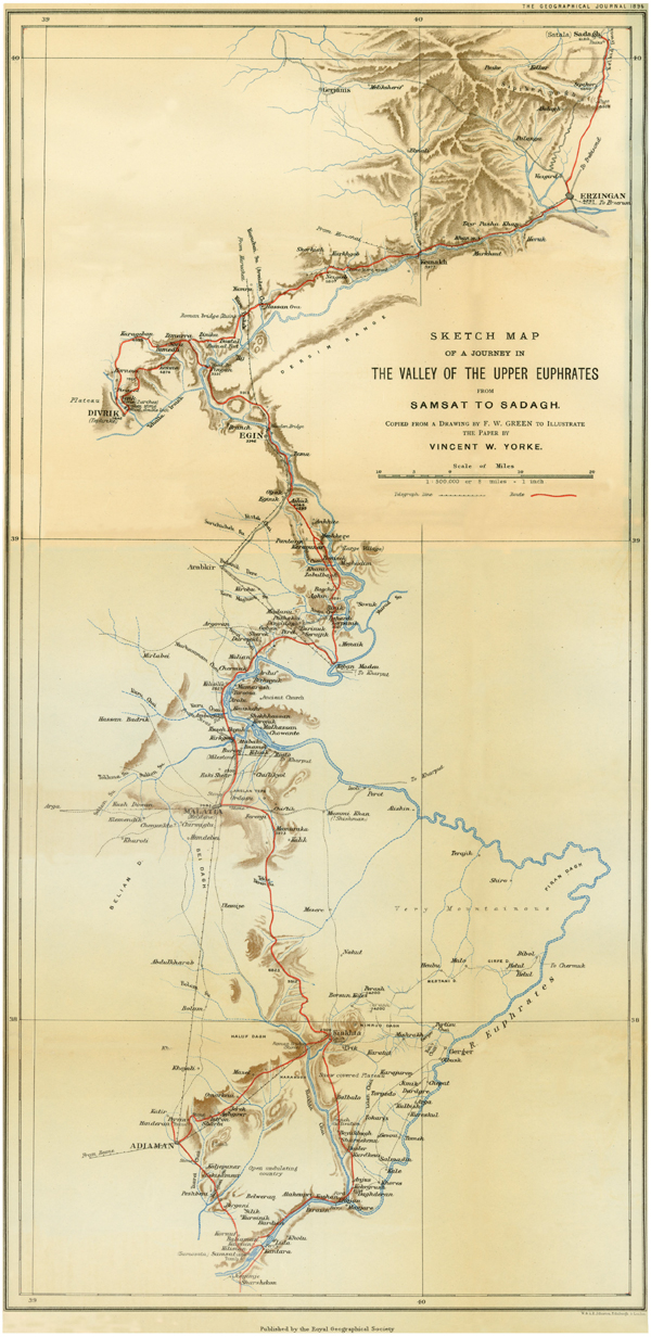
MR. YORK’S MAP-The map of the valley of the Upper Euphrates has been constructed by Mr. F. W. Green. The bearings were taken by prismatic compass, distances estimated by time, and the heights above the sea-level obtained by aneroid. Some of the detail has been added from Captain Maunsell’s Survey, 1892, and other sources.
However, Hogarth, Munro and Yorke were primarily interested in historical geography – identifying remains of milestones, aqueducts, inscriptions, and other past cultural remains. This, of course, did not preclude an interest in accurate cartography. Archaeological interest on the part of military cartographers is shown in the number archaeological expedition sources used for the series. There seems to have been a symbiotic relationship between cartographers and archaeologists. Maunsell himself was also not immune to doing a little bit of digging. Another intersection with the BSA occurred in 1910 when A.J.B. Wace and M.S. Thompson presented their work on ‘The Distribution of Early Civilization in Northern Greece’ at the Geographical Society’s meetings. It was published the following year in The Geographical Journal along with a synopsis of the discussion that followed the talk. Among the discussants was F.R. Maunsell who remarked:
I have never actually been in Thessaly, but I was struck by a curious fact on looking at the photographs which the lecturer has shown us. When Consul at Van, in Asiatic Turkey, we excavated some low mounds in the plain near the town, and discovered, quite by accident, many Neolithic remains, including pottery, household implements, bone needles, flint knives, stone hammers, and some other objects which were almost exactly the same as those shown in the photographs coming from Thessaly. There was one piece of pottery which had just the same zigzag pattern trace in reddish paint.
These intersections are not surprising given the wide range of interests and backgrounds of the Fellows of the Royal Geographical Society – explorers, archaeologists, naval hydrographers and military cartographers, geologists and others with an interested in geography. The Society was a focal point for the exchange of information and ideas, and the library of the Society would have provided a wealth of source material.
Hogarth, D.G. and Munro, J.A.R. 1893. ‘Modern and Ancient Roads in Eastern Asia Minor’, Supplementary Papers of the Royal Geographical Society, 3(5): 643–739.
Geographical Society. 1896. ‘A Journey in the Valley of the Upper Euphrates: Discussion’, The Geographical Journal, 8(5): 472–474.
Geographical Society. 1911. ‘The Distribution of Early Civilization in Northern Greece: Discussion’, The Geographical Journal, 37(6): 636–642.
Ramsay, W.M. 1890. The Historical Geography of Asia Minor. London: John Murray.
Wace, A.J.B. and Thompson, M.S. 1911. ‘The Distribution of Early Civilization in Northern Greece’, The Geographical Journal, 37(6): 631–636.
Yorke, V.W. 1896. ‘A Journey in the Valley of the Upper Euphrates: Part I. The Journey’, The Geographical Journal, 8(4): 317–335.
Yorke, V.W. 1896. ‘A Journey in the Valley of the Upper Euphrates’, The Geographical Journal, 8(5): 453–472.
***
Deborah Harlan
British School at Athens
The BSA Map Collection is catalogued on the BSA’s Digital Collections page.
The on-line catalogue of the Royal Geographical Society can be found here: https://www.rgs.org/about/our-collections/search-our-collections/
Click here for more BSA Library Stories.
