Events Calendar – British School at Athens

- This event has passed.
Friends’ Lecture series
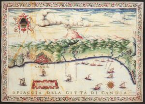
Dr Kostis Christakis (BSA Knossos Curator), “A land called Crete: European cartographers and the perception of the Cretan landscape, 16th – 17th c. AD“
This is an exclusive event for BSA Supporters only. If you would like to join us, please consider signing up as a Supporter for as little as £50 (£20 for students) if you have not already done so. You can find out more, and sign up, here.
Abstract: The extent of the cartographic depiction of Crete during the Renaissance and the Enlightenment is undoubtedly unique. No other area of Greece, including Cyprus, has been represented in such a vast array of printed maps and topographical plans. This presentation discusses how cartographers depicted the Cretan landscape, both natural and anthropogenic, and highlights the evidence that maps can provide on the complex and changeable political, economic and ideological aspects of Cretan society in the Late Venetian period.
Bio: Dr Kostis S. Christakis is the Curator at the Knossos Research Centre of the British School at Athens and is a former lecturer at the University of Crete. His publications include four monographs and various articles, concerning topics related to the economic and political organization of Bronze Age Crete, household archaeology, subsistence economy and pottery. He co-directs the excavation and publication project at Galatas Pediados and he is responsible, among others projects, for the final publication of Bronze Age Complexes at the sanctuary of Hermes and Aphrodite at Syme Viannou (stratigraphy and pottery) and of the storerooms of the palace at Knossos.
Online only, 5pm (UK) / 7pm (Greece)
When: 24 October, 2023 @ 5:00 pm - 6:30 pm BST
Where: – –
